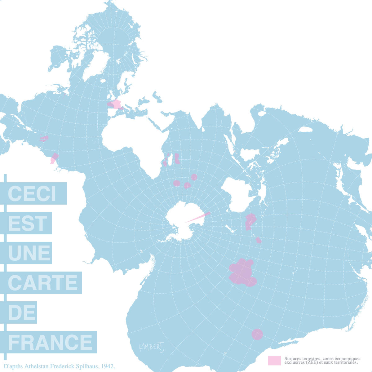
France ocean territory (Spilhaus projection)
The #WorldOceansDay is an initiative from the Rio Summit. It takes place every June 8th since 1992. So what better than this interactive map to remind us today of the central place of the oceans in our environment?
How to draw the World ?
In their daily work, cartographers are faced with a tricky problem. How to represent a spherical world in three dimensions on a two-dimensional screen? To solve this question, which allows to make the immensity of the world visible at a glance (which is not possible on a globe), many mathematical processes have been used since antiquity, gathered under the name of cartographic projections (or projection systems). The existing methods are multiple. They are based on planes, cylinders or cones which, once unrolled, give particular shape to the planispheres (i.e. flat spheres) thus formed. As you can see, each of these transformations has a concrete impact on the shape of the map thus produced and inevitably leads to deformations. Some maps will therefore tend to faithfully respect the shape of the different countries, while others, on the contrary, will favor the surface ratios. This is the famous opposition between the Mercator map and the Gall-Peters map described here. In the end, there are a thousand and one ways to draw the world and the choice of a particular projection is always a function of the cartographer's communication intentions. Let's also note that these are almost always designed to privilege the representation of land. But other choices are possible.
The Spilhaus World Ocean
The map presented here was imagined in 1942 by the South African oceanographer Athelstan Frederick Spilhaus. Initially presented as a square, it pushes the countries to the edges of the map while a single massive ocean surface is enthroned in its center. The Pacific Ocean alone covers an area of more than 150 million km², which is as much as the entire land mass. The oceans also produce at least 50% of the planet's oxygen and are home to a considerable biodiversity representing half of the living species on our planet. Finally, unlike the continents, the oceans are all connected to each other to form a single world ocean on this map. The Spilhaus map therefore aims to put back in the center of the game these oceanic masses that are often cut off and relegated, insignificant, to the edges of the map as if they were a simple element of the stage.
Another map of France
Taking into account maritime spaces also means not considering our own territory only in its land dimension. Here on this map, all the French territories throughout the world are represented, in their terrestrial component but also maritime (exclusive economic zones and territorial waters). What do we see? First of all, that 94% of the French territory is composed of water against only 6% of dry land. It is the largest maritime area in the world. Moreover, this "decentered" and "distorted" map shows a France that is not located mainly in Europe. Indeed, 92% of its territory is located elsewhere in the world. One can see in this the trace of a not very glorious colonial past but also, why not, the fact that France is, in all its extent, a universal and mainly non-Western maritime power.
In summary, another way of looking at things that invites us to think differently about our place in the world.
The text in french is avaiable here
D'après Athelstan Frederick Spilhaus, 1942.Surfaces terrestres, zones économiquesexclusives (ZEE) et eaux territoriale